In a world that moves fast, walking helps us slow down, look and listen. In the North York Moors National Park, every step of your walk brings you closer to nature – the crunch of boots on earth, the hush of wind through ancient woods, the sight of wild heather stretching to the horizon. Listen also for the sound of the call of moorland birds, such as red grouse, curlew and golden plover.
With over 1,400 miles of paths and trails, there’s a route for every kind of recreational and keen walker. Wander alone or with company, go slow or stride out. Here, the journey and experience matters more than the destination.
So, lace up your boots and step out into nature and enjoy the beautiful scenery the North York Moors offers.

Walking on North York Moors
Lovely Walking Routes in the North York Moors
Here is a selection of nine lovely walks and hiking trails from 2 to 11 miles. Each can be explored and enjoyed whilst staying at our Helmlsey Hideaway in Harome, near Helmsley. There is a combination of easy to challenging walks that can be selected, depending on fitness, weather, time and desire!
Detailed route maps and guides are available for each of the walks in and around the North York Moors National Park. These resources will assist you in planning and navigating your walking adventure:

Lovely Local Dog Walks
-
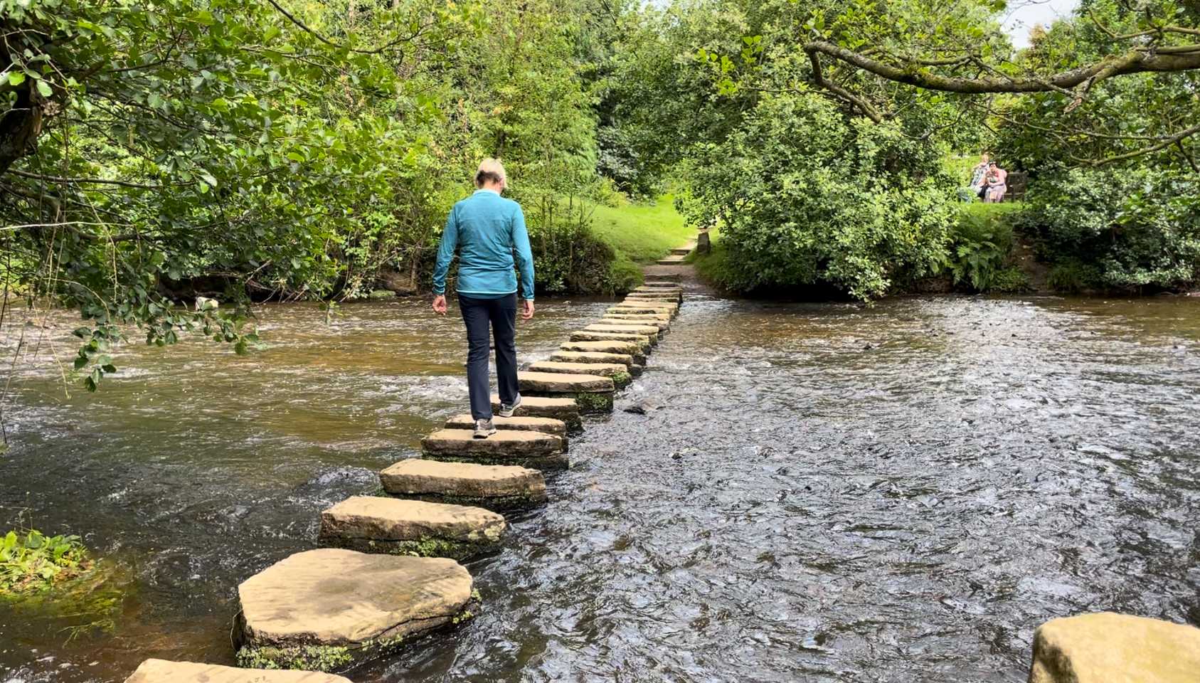
Harome to Nunnington Circular Walk
Ramble through a lovely mix of riparian, woodland and farmland habitats on this 6 mile circular walk. This easy route passes through a range of habitats, affording the chance to see a wide variety of species and environments. Roam the babbling becks, stand beneath an ancient tree, take note of the shimmering, bright blue feathers of a kingfisher as it perches on a branch. Great for: Spotting dippers, otters and pied wagtails along the river.
Distance: Approximately 6 miles (9.6 km)
Difficulty: Moderate
More Information & Walk details: Harome to Nunnington Circular • Hiking Trail » outdooractive.com
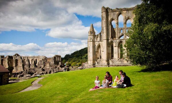
Family-at-Rievaulx-Abbey-please-credit-Chris-J-Parker
-
Rievaulx Abbey and the Rye Dale Valley
Route Map & Guide: Beginning in the market town of Helmsley, this walk follows the Cleveland Way to the historic ruins of Rievaulx Abbey. The trail then loops through the tranquil Rye Dale valley, passing through woodlands and pastures, and offers a blend of natural beauty and historical significance.
Distance: Approximately 11 miles (17.7 km)
Difficulty: Moderate
More Information & Walk details: Rievaulx Abbey and the Rye Dale Valley – Outdoor Active
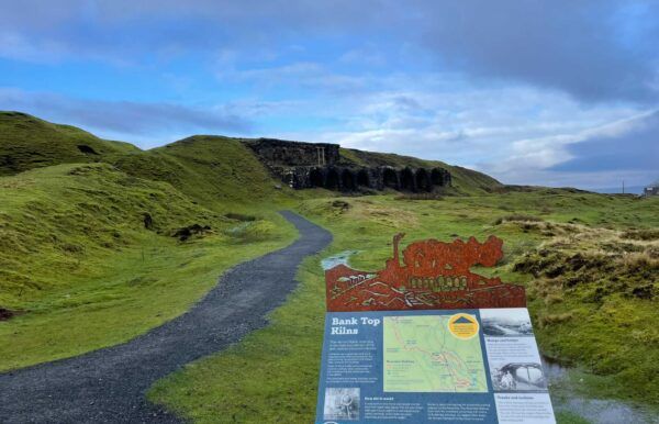
Bank Top Kilns – Rosedale Chimney
-
Rosedale Circular Walk
Stroll through rolling valleys. A peaceful circular walk through one of the most picturesque dales in the North York Moors. Follow quiet lanes, riverside paths, and old railway lines as you take in the rolling hills, historic mining remnants, and the timeless charm of the village of Rosedale Abbey.
Distance: Approximately 7.5 miles (12 km)
Difficulty: Moderate
More Information & Walk details: Rosedale • Hiking Trail » outdooractive.com
-
Goathland to Grosmont via the Rail Trail
Route Map & Guide: This gentle route follows a disused railway line that once served the Whitby-Pickering route. The path passes through woods and alongside streams, with the chance to spot steam trains from the North Yorkshire Moors Railway. A detour to Mallyan Spout waterfall is a rewarding side trip.
Distance: Approximately 3.5 miles (5.6 km)
Difficulty: Easy
More Information & Walk details: All Trails
-
Levisham Moor & Hole of Horcum
Explore stunning landscapes and one of the most dramatic natural features in the North York Moors. This scenic loop across open moorland leads you to the legendary Hole of Horcum – a vast natural amphitheatre, bowl-shaped valley steeped in folklore. The path then descends into the hollow and returns through a scenic valley, offering stunning views, especially when the heather is in bloom.
Distance: Approximately 5.2 miles (8.3 km)
Difficulty: Easy to Moderate
More Information & Walk details: North York Moors Hole of Horcum Circular
The Cleveland Way – North York Moors Coastline
-
Robin Hood’s Bay to Whitby (Cleveland Way)
Route Map & Guide: This section of the Cleveland Way national trail offers dramatic sea views, steep cliff paths, and a rich maritime history. Starting in the quaint fishing village of Robin Hood’s Bay, you’ll follow the coastline north to the gothic town of Whitby, known for its connections to Dracula and Captain Cook.
Distance: Approximately 7 miles (11.1 km) one way
Difficulty: Moderate
More Information & Walk details: Plot your Route
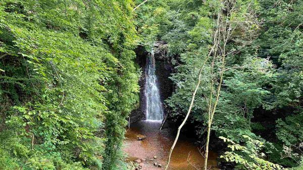
Falling Foss waterfall
7. May Beck & Falling Foss
A short but magical woodland walk leading to the enchanting Falling Foss waterfall. Ideal for families and slower-paced days, this route winds through leafy paths alongside May Beck and finishes with a perfect picnic spot by the falls.
Distance: Approximately 2 miles (3.1 km)
Difficulty: Easy
More Information & Walk details: May Beck and Falling Foss • Hiking Trail » outdooractive.com
-
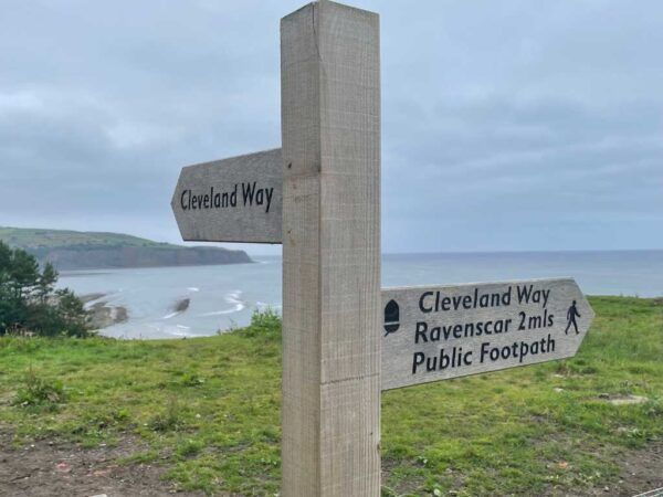
Ravenscar to Robin Hood’s Bay
Breathe in the coastal air. This breathtaking circular walk begins and ends in Ravenscar, following the dramatic Cleveland Way clifftops to the historic village of Robin Hood’s Bay. Enjoy panoramic sea views, rich wildlife, and a mix of moorland and coastal scenery throughout.
Distance: Approximately 10.6 miles (17.1 km)
Difficulty: Challenging
More Information & Walk details: Ravenscar to Robin Hood’s Bay • Hiking Trail » outdooractive.com
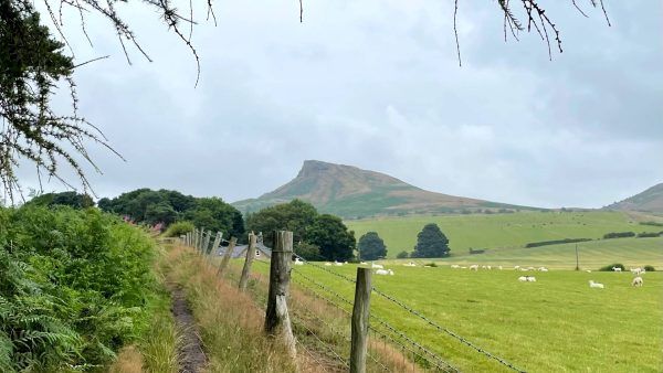
Roseberry Topping – A lovely walk
-
Roseberry Topping and Newton Moor
Route Map & Guide: This walk starts from Newton under Roseberry and ascends to the distinctive summit of Roseberry Topping, offering panoramic views of the surrounding moorland. The route then continues across Newton Moor, showcasing the area’s heather-covered landscapes.
Distance: Approximately 3.2 miles (5 km)
Difficulty: Moderate
More Information and maps: Roseberry Topping & Newton Moor
Additional Useful Information
- A Guide to Unmissable North York Moors Walks and Hikes – https://www.paulbeal.com/north-york-moors-walks/
- The North York Moors – Where do you want to walk today?
- Countryfile – Best walks in the North York Moors National Park
- All Trails – Best trails in North York Moors National Park
- Runswick Bay to Kettleness Circular Walk
- Walking the Spectacular Views at Sutton Bank National Park
- Helmsley Castle, Duncombe Park & Fairy Steps Circular Walk
- Lovely Local Walks around Harome – Explore the Countryside
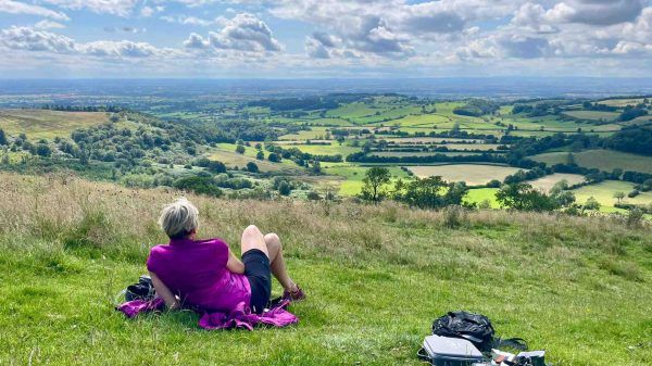
Enjoying the views at Sutton Bank